REFRESH Nelson County Life Magazine HERE
Forecast By Tommy Stafford – Nelson County Life Magazine
LISTEN TO THE WEATHER BY PRESSING THE BUTTON.
Photography By John Taylor
Nelson County Life Magazine ©2008
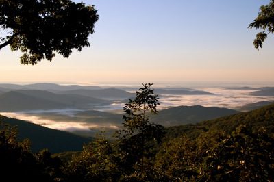
Fog In The Valley
Looking East Past Blackrock Mountain at Wintergreen toward Nellysford & Scottsville.
Wintergreen Mountain, Virginia
Today’s weather and is brought to you exclusively by:

Click the red play button above to hear the latest specials at a.m. Fog!
“Thirsty Third Thursdays” wine tasting, at a.m. Fog. featuring DelFosse Wines which are sold there! The next one is scheduled for August 21st!
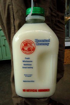
Homestead Creamery milk available in the farm market at a.m. Fog. This is the real thing in those familiar glass bottles. It gets delivered fresh every Wednesday!You can always visit them on the web at www.amfog.net or call ’em at 540-456-7100

Rainfall totals as of 11:59 PM EDT Monday night:
–MONDAY’S High / Low at NCL-Nelson County Life Magazine in the Rockfish Valley : 83°/52° – RAIN : 0.02″ – YTD: 17.01″
–MONDAY’S High / Low at NCL-TWNF on Devil’s Knob @ Wintergreen Mountain : N/A°/N/A° – RAIN 0.12″ – YTD: 24.62″
–MONDAY’S High / Low at NCL-Hatcreek Farm on Horseshoe Mountain @ Roseland, VA : 78°/51°– RAIN : 0.00″ – YTD: 24.83″
–MONDAY’SHigh / Low at NCL-Tiger Fuel @ Lovingston, VA : 78°/53° – RAIN : 0.02″ – YTD: 22.29″
–MONDAY’S High / Low at NCL-Delfosse Winery & Vineyard @ Faber, VA : 80°/55° – RAIN : 0.00″ – YTD: 17.93″
Thanks once again to John Taylor for this morning’s weather photo. This is another nice one after the rainbow he sent yesterday. This is morning fog down in the valley looking east past Black Rock Mountain at Wintergreen toward Nellysford & Scottsville. We’re getting into the time of the year where fog begins forming on these cool nights, especially when there’s been any rain at all.
Also had a question Monday sent in by NCL web reader Nancy Maxson about the Perseid meteor showers:
“Hi Tommy!
Say, when’s the best time to view the coming Perseid shower this year?
I’ve heard anywhere from 9 pm to not before 3 am.
And what’s the weather forecast for viewing, cloudy or worth the trip up to
the parkway? Thanks and enjoy!
Nancy”

Stefan Seip took this picture over Riedseltz, France. The image shows the Milky Way in the Cepheus and Summer Triangle region. It shows also 6 Perseids and one Non-Perseid meteor. August 12/13, 2005 22:32 – 1:28 UT. Camera: Canon EOS 20Da, tracking the stars. Lens: Canon EF-S 10-22mm @ 11mm f/4 ISO 1600. Exposure time for the background: 10x 2 minutes. Credit: Stefan Seip. Courtesy www.space.com
Well, Nancy with a little research here’s what I have found out from an article on www.space.com last night:
“The best time to watch, regardless of your location, is from 2 a.m. to dawn local time, but the best seats will be in the western half of North America where dark skies coincide with the peak activity.
The Perseids get their name from the constellation Perseus, from which they tend to emanate like spokes from the hub of a wheel. The meteors can make their appearance anywhere in the sky, however.”
The absolute peak was this morning on the 12th, but don’t let that disappoint you, there’s still some mornings left to view the showers that will continue over the next several early mornings.
The BRP is a great location to view from because you get away from any light noise, but if you have a rural location away from lights here in the valley, you should still be in great shape! The weather for the next couple of nights should be very good for viewing!
Good luck Nancy, and thanks for the question!
Weatherwise, we’ll continue with the really nice weather. Yesterday was spectacular with low humidity along with low pleasant temps and a nice northerly breeze making it feel great all day long! Last night was really cool almost chilly with 40’s and 50’s for lows, allowing folks to open the windows and enjoy the crisp cool air!
Today will be a tad warmer, but the humidity will still be low, so it will still feel nice with a light westerly breeze. By Wednesday winds become more southerly allowing increases in humidity levels, but still nice for August with temps in the low and mid 80’s right through the weekend.
There’s some activity brewing out in the Atlantic as well that may eventually warrant watching for tropical storm / hurricane development. You can view more on the activity by clicking here. We will add more updates if this develops and / or moves closer to the East Coast interests.
![]()
Eastern U.S. Regional Current Surface Map via wunderground

Looking 12-24 Hours Ahead
Your Nelson County Life custom area forecast including: Wintergreen Mountain, Black Rock Mountain, Ivy, and Heards.
TUESDAY: Sunny and warm, continued low humidity.
* Highs Valley: 84-87°
*On the mountains: 71-74°
*Winds: W-5 MPH
*OVERNIGHT: Clear & mild. Lows valley: 62-65° : Mountains: 59-62° : Winds: Becoming L & V
WEDNESDAY: Mostly sunny & warm with an isolated afternoon thunderstorm, mainly west of the BRP
* Highs Valley: 83-86°
*On the mountains: 73-76°
*Winds: S 5-10 MPH
*OVERNIGHT: Becoming mostly cloudy. Lows valley: 63-66° : Mountains: 60-63° : Winds: S-5 MPH becoming L & V
EXTENDED OUTLOOK
THU: M/C 85/59
FRI: M/C T-Storm 85/60
SAT: M/C 83/63
SUN: P/S 82/63
MON: M/C T-Storm 84/64
All mountain temperatures in the extended period roughly 10-15 degrees cooler than those listed in the valley for afternoon highs.
Have a great Tuesday!
