REFRESH Nelson County Life Magazine HERE
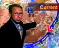
Forecast By Tommy Stafford – Nelson County Life Magazine
AUDIO WEATHER UNAVAILABLE UNTIL THURSDAY READ MORE BELOW
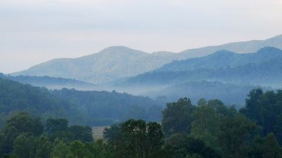
Photography By Ann Strober
Nelson County Life Magazine ©2008
Morning Fog In The Rockfish Valley
Nellysford, Virginia
Today’s weather and is brought to you exclusively by:

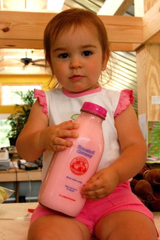
Olivia Harris of a.m. Fog Shows Off One of The Homestead Creamery Varieties
Afton, Virginia
Most of you know by now that Yvette and I are expecting a child in the fall of this year. Yea, she’s been drinking the milk lots to keep up the calcium! She’s always liked Homestead Creamery milk. You know, it comes in those classic glass bottles, not far off of the kind the milkman used to deliver in simpler times. Most of the stores around here carried it, then one day she walked in and no more! Gone.
Folks this is one popular brand of milk and it’s the best around. No artificial hormones, and about as close to the cow as it comes! Yea, move over happy steer, we’ve got the happy cow now! As soon as Ken and Yvonne Harris up at a.m. Fog heard about this they jumped all over it! And, yep! They have the whole line of Homestead Creamery milk products in the familiar glass bottles, right there in their market on the Nelson-Albemarle County line on Route 151.
Nothing’s quite as good as a cold glass of milk from one of those chilled bottles!
And now you can get Homestead Creamery milk just up the road at a.m. Fog. along with all of your vegetables, plants and nursery needs to boot!
You can always visit them on the web at www.amfog.net or call ’em at 540-456-7100
Weather readings for Tuesday unavailable due to server malfunction at www.wunderground.com – read more below.
–TUESDAY’S High / Low at NCL-Nelson County Life Magazine in the Rockfish Valley : N/A°/N/A° – RAIN : 0.00″ – YTD: 16.47″
–TUESDAY’S High / Low at NCL-TWNF on Devil’s Knob @ Wintergreen Mountain : N/A°/N/A° – RAIN 0.00″ – YTD: 23.95″
–TUESDAY’S High / Low at NCL-Hatcreek Farm on Horseshoe Mountain @ Roseland, VA : N/A°/N/A°– RAIN : 0.00″ – YTD: 23.94″
–TUESDAY’S High / Low at NCL-Tiger Fuel @ Lovingston, VA : N/A°/N/A° – RAIN : 0.00″ – YTD: 21.11″
–TUESDAY’S High / Low at NCL-Delfosse Winery & Vineyard @ Faber, VA : N/A°/N/A° – RAIN : 0.00″ – YTD: 8.42″
–TUESDAY’S High / Low at NCL-Mini Tara Vineyards @ Arrington, VA : N/A°/N/A° – RAIN : 0.00″ – YTD: 5.00″
A quick thanks to Ann Strober of Nellysford for the great shot of the fog in the Rockfish Valley this week. We’ve had several mornings of fog as the nighttime air becomes damp and allows it to form in the valley.
As we have talked about before, lots of our weather data goes through a a weather server called www.wunderground.com up in Michigan. It links all of the data our NCL-Weathernet stations gather and then puts it on the internet where it can be seen. Yesterday their servers took a major hit, it appears to be a hacker attack at this point, and as of late last night they still weren’t back up. So … we can’t get to most of our data and many of the maps we use here on the site. Some maps and temperature readings will be missing until this is resolved.
Thankfully we won’t be needing it for a few more days, the forecast is basically sunny and warm, hot even, with chances for rain by the weekend.
Until all of this is sorted out, here is the generic NWS forecast. Hopefully we will have all of this working by Thursday.
Regional Current Surface Map via wunderground
![]()
Looking 12-24 Hours Ahead

Your Nelson County Life custom area forecast including: Nellysford, Gladstone, Wintergreen, and Adail.
ZONE FORECAST PRODUCT
NATIONAL WEATHER SERVICE BALTIMORE MD/WASHINGTON DC
VAZ036>038-160930-
NELSON-ALBEMARLE-GREENE-.WEDNESDAY…SUNNY. HIGHS IN THE UPPER 80S. EAST WINDS AROUND 5 MPH.
.WEDNESDAY NIGHT…MOSTLY CLEAR. LOWS AROUND 60. EAST WINDS AROUND
5 MPH IN THE EVENING…BECOMING LIGHT AND VARIABLE.
.THURSDAY…SUNNY. HIGHS IN THE LOWER 90S. NORTHEAST WINDS AROUND
5 MPH…BECOMING EAST AROUND 5 MPH IN THE AFTERNOON.
.THURSDAY NIGHT…MOSTLY CLEAR. LOWS IN THE MID 60S. SOUTHEAST WINDS
AROUND 5 MPH IN THE EVENING…BECOMING LIGHT AND VARIABLE.
.FRIDAY…MOSTLY SUNNY. HIGHS AROUND 90.
.FRIDAY NIGHT…PARTLY CLOUDY. LOWS IN THE UPPER 60S.
.SATURDAY…PARTLY SUNNY WITH A CHANCE OF SHOWERS AND THUNDERSTORMS.
HIGHS IN THE UPPER 80S. CHANCE OF RAIN 30 PERCENT.
.SATURDAY NIGHT…MOSTLY CLOUDY WITH A CHANCE OF SHOWERS AND
THUNDERSTORMS. LOWS IN THE UPPER 60S. CHANCE OF RAIN 30 PERCENT.
.SUNDAY…PARTLY SUNNY WITH A CHANCE OF SHOWERS AND THUNDERSTORMS.
HIGHS AROUND 90. CHANCE OF RAIN 30 PERCENT.
.SUNDAY NIGHT…MOSTLY CLOUDY WITH A CHANCE OF SHOWERS AND
THUNDERSTORMS. LOWS IN THE UPPER 60S. CHANCE OF RAIN 30 PERCENT.
.MONDAY…PARTLY SUNNY WITH A CHANCE OF SHOWERS AND THUNDERSTORMS.
HIGHS IN THE UPPER 80S. CHANCE OF RAIN 30 PERCENT.
.MONDAY NIGHT…MOSTLY CLOUDY WITH A CHANCE OF SHOWERS AND
THUNDERSTORMS. LOWS IN THE UPPER 60S. CHANCE OF RAIN 30 PERCENT.
.TUESDAY…PARTLY SUNNY WITH A CHANCE OF SHOWERS AND THUNDERSTORMS.
HIGHS IN THE MID 80S. CHANCE OF RAIN 30 PERCENT.
FORECAST FOR ELEVATIONS ABOVE 2000 FEET:
.WEDNESDAY…SUNNY. HIGHS IN THE UPPER 70S.
.WEDNESDAY NIGHT…MOSTLY CLEAR. LOWS IN THE MID 50S.
.THURSDAY…SUNNY. HIGHS IN THE MID 80S.
.FRIDAY…PARTLY CLOUDY. LOWS AROUND 60. HIGHS IN THE LOWER 80S.
.SATURDAY…PARTLY CLOUDY. A CHANCE OF SHOWERS AND THUNDERSTORMS IN
THE AFTERNOON AND EVENING. LOWS IN THE MID 60S. HIGHS IN THE MID
80S.
.SUNDAY…MOSTLY CLOUDY. A CHANCE OF SHOWERS AND THUNDERSTORMS IN
THE AFTERNOON AND EVENING. LOWS IN THE MID 60S. HIGHS IN THE MID
80S.
Have a great Wednesday!
