REFRESH Nelson County Life Magazine HERE
Forecast By Tommy Stafford – Nelson County Life Magazine
![]()
Regional Animated Radar
LISTEN TO THE WEATHER BY PRESSING THE BUTTON.
Photography By Steve Crandall
For Nelson County Life Magazine ©2008
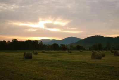
Sunrise In Nelson
Nelson County, Virginia
Today’s weather and is brought to you exclusively by:

It takes a long, long time to get really good at growing tasty vegetables and everything else on the farm for that matter. Thankfully you don’t have to wait to be an expert! Ken and Yvonne Harris at a.m. Fog on the Nelson-Albemarle County Line in Afton do it for you.
Spinach, kale, brocoli, cabbage and veggie start, along with 6 kinds of lettuce and 26 types of heirloom tomatoes and sweet or HOT peppers are just some of what you’ll find at their new farm market right on Route 151. They even have pineapple and watermelons to boot!
I never would eat asparagus as a kid but now I love it, and they have plenty of it. Try grilling it sometime with just a touch of olive oil and pepper! Mmm, mm. Then there’s , meat, and fresh baked bread along with a so many other vegetables I can even list them all.
The beautiful new farm market is OPEN FOR BUSINESS NOW!
You can always visit them on the web at www.amfog.net or call ’em at 540-456-7100.
–MONDAY’S High / Low at NCL-Nelson County Life Magazine in the Rockfish Valley : 88°/48° – RAIN : 0.02″ – YTD: 14.18″
–MONDAY’S High / Low at NCL-Wintergreen Nature Foundation on Devil’s Knob @ Wintergreen Mountain : 76°/56° – RAIN 0.04″ – YTD: 20.50″
–MONDAY’S High / Low at NCL-Hatcreek Farm on Horseshoe Mountain @ Roseland, VA : 84°/48° – RAIN : 0.00″ – YTD: 20.16″
–MONDAY’S High / Low at NCL-Tiger Fuel @ Lovingston, VA : 85°/50° – RAIN : 0.00″ – YTD: 8.77″
–MONDAY’S High / Low at NCL-Delfosse Winery & Vineyard @ Faber, VA : 85°/55° – RAIN : 0.00″ – YTD: 8.42″
A quick thanks to Steve Crandall of Roseland for sending us the beautiful shot above for today’s weather photo. It’s a wonderful sunrise he caught driving north on 151.
The Memorial Day Holiday has come to an end, and for all but the last hour or two before dark yesterday it was a completely perfect weekend. Last last evening very isolated showers popped up along the Blue Ride Parkway and moved east into parts of Nelson. Overall, everyone stayed dry, but a few stations on the mountain and just east of the BRP picked up anywhere from a trace to .04″.
Today we’ll see some scattered showers, maybe a clap of thunder early, with a lull, then more development of significant thunderstorms in the afternoon in advance of an approaching cold front. To our west and north that front has been responsible for deadly tornadoes over the Memorial weekend. At least right now it doesn’t appear the front will have that kind of kick to it here. Though isolated severe weather is possible, an organized system is not likely at this point. But, with any sunshine we might get between storms Tuesday, that would help destabilize things and increase the chances for a severe storm or two. This time of year as we head from cooler drier air to more humid conditions, the chances for unannounced afternoon thunderstorms is always a possibility, even when they aren’t forecast.
After the rain moves out sometime Wednesday morning, the remainder of the week looks nice and mostly sunny with daytime highs cooler Wednesday & Thursday, but quickly rebounding to the 80’s by Friday. A chance for scattered thunderstorms returns by Sunday.
Regional Current Surface Map via wunderground
![]()
Looking 12-24 Hours Ahead

Your Nelson County Life custom area forecast including: Nellysford, Piedmont, Norwood, and Dixon Landing.
TUESDAY: Mostly cloudy with scattered T-Storms in the morning, some sun, then T-storms returning in the afternoon.
* Highs Valley: 83-86°
*On the mountains: 76-79°
*Winds: SW 10-15 MPH gusting to 25 MPH
*OVERNIGHT: Thundershowers in the evening, then partly cloudy after midnight. Lows valley: 56-59° : Mountains: 50-53° : Winds: W 5-10 MPH becoming N & gusty after midnight.
WEDNESDAY: Becoming mostly sunny and cooler.
* Highs Valley: 69-72°
*On the mountains: 60-63°
*Winds: NE 10-15 MPH
*OVERNIGHT: Mostly clear and cool. Lows valley: 46-49° : Mountains: 41-44° : Winds: NE-5 MPH becoming L & V.
THU: Mo/Sunny 72/53
FRI : Mo/Sunny 80/57
SAT : Mo/Sunny 84/61
SUN : P/S T-Storms 80/59
MON: M/C Showers 76/51
All mountain temperatures in the extended period roughly 10 degrees cooler than those in the valley listed.
Have a great and safe Tuesday everyone!

Want to have Jan & The Honeybirds play at your special event, click on the image above to find out how!
Or visit their website by clicking here.

Today’s cut is Gorham Mountain from her CD Tin Heart.
Louisville, Kentucky native Jan Smith writes songs rooted in vibrant imagery and sincere, stark emotion. The artists whose music she grew up with — Merle Haggard, Nina Simone, and Townes Van Zant among many others – influence her work, as does the traditional bluegrass music of her new home in the mountains of central Virginia.
On April 4, 2006, Landslide Records released “29 Dances,” produced in Nashville by Bil VornDick (Alison Krauss, Ralph Stanley). The record features Johnny Hiland, Byron House (Sam Bush, Nickel Creek), Pat McInerney (Nanci Griffith), Randy Kohrs, David Talbot (the Grascals), Mark Fain (Ricky Skaggs), Robert Bowlin (Bill Monroe), Patty Mitchell, and Smith’s partner, Jeff Vogelgesang.
