REFRESH Nelson County Life Magazine HERE for the latest updates:
Weathercast by Tommy Stafford, Nelson County Life Magazine
AUDIO VERSION OF FORECAST (some PC users may need to click play button twice)
Photography by Tommy Stafford
For www.NelsonCountyLife.com : Copyright 2007
Remembrance of Things Past
Spruce Creek Gallery
Nellysford, Virginia
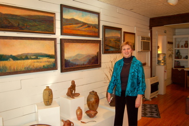
Above artist, Christine Rooney, of Lynchburg poses near some of her artwork on display at Spruce Creek Gallery just south of Nellysford on 151. Her exhibit called, Remembrance of Things Past is is series of new paintings on display through October 28th. “My desire is to present landscapes where the viewers feel they have been somewhere or sometime. Places that evoke reflection, renewal, and peace. Trees, land and light become symbols of individuality, physical space and spirituality. All my paintings are of real places, mostly in Nelson County, but seen through ‘new eyes,” says Rooney.
Listen to Christine talk about her art on display and how she got her start as a youngster.
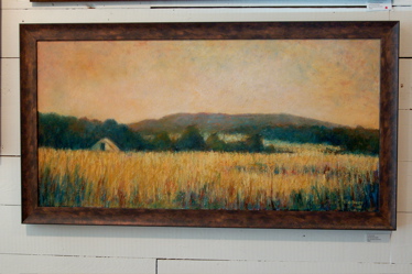
A closer look at some of Rooney’s beautiful work.
Well we can say “so long” to the really hot weather now. Tuesday should finish us up with that 90 degree business, barring any crazy hot spells in the coming weeks. NCL-Wintergreen Winery fell just short of the 100 degree mark on Tuesday by just 3 degrees. All of the other NCL-Weathernet stations, hit 90 or above as well, except obviously Devil’s Knob. We should be trending toward cooler days right on through the end of the year. The calendar sure says it. Normal highs for this time of the year should be in the low 70’s for daytime highs and upper 40’s for nighttime lows. We see some 80’s today, but after that 60’s will be the order for highs warming to the 70’s by late in the weekend. We did see a smattering of rain yesterday, mainly west of the BRP in the Shenandoah Valley, but most of Nelson once again missed any significant rainfall. Unfortunately, our previous chances for rain this coming weekend have lessened as well, with only slight chances for a shower. The extended outlook doesn’t show much either. That said, this time of year as we transition into fall, only slight changes in a weather pattern can make all of the difference. As you have heard me say in the past, extended outlooks are very inaccurate and I have little to no faith in them. So we’ll see what the trend is over the next 7 days as it unfolds.
And for those of you keeping the HOT Tuesday scores at home, The numbers as of 11:59 PM EDT last night
*NCL-Nelson County Life Magazine : Greenfield / Afton, VA
Tuesday High: 94.1°
0.00″ of rain
*NCL-Wintergreen Nature Foundation : Devil’s Knob, VA
Tuesday High: 84.4°
0.00″ of rain
*NCL-Wintergreen Winery @ the foot of Wintergreen Mountain in Beech Grove, VA
Tuesday High: 97.2°
0.00″ of rain
*NEW*NCL-Hatcreek Farm on Horseshoe Mountain : Roseland, VA
Tuesday High: 95.0° estimated
0.00″ of rain
*NCL-Delfosse Winery & Vineyard : Faber, VA
Tuesday High: 93.7°
0.00″ of rain
*NCL-Tiger Fuel – Lovingston, VA
Tuesday High: 93.0°
0.00″ of rain
*Covesville Store : Covesville, VA
Tuesday High: 90.5°
0.00″ of rain
Today’s Forecast Map

The National Forecast Map has a couple of cold fronts crossing the area. One overnight last night and a reinforcing one over the next 24 hours. Notably cooler high pressure builds in for the remainder of the week, certainly making it feel like Fall again … finally!
Local forecast
*Today Mostly sunny early, then partly sunny in the afternoon, cooler.
*High temps in Spruce Creek, Gladstone, & Rockfish Gap around 84°
*On the mountains above 2000 feet along the BRP, Montebello, Wintergreen, Devil’s Knob, and Love, Mostly sunny early then some passing clouds by afternoon.
Highs top out around 71°
Winds: NNW 5-10 MPH
*Tonight Partly cloudy & pleasant.
*Lows valley near 51°
*On the mountains overnight low near 45°
*Winds: NW 4-8 MPH
Thursday Partly sunny & cool.
*Highs valley 68°
*On the mountains much cooler with a high around 56°
Winds: NW 6-8 MPH
*Thursday night: Partly cloudy to mostly cloudy – Lows near 43° valley & 38° mountains.
Winds: W 5-10 MPH gusts to 15.
The remainder of the week Friday looks partly sunny & mainly dry. Daytime highs in the upper 60’s valley cooling to the mid 60’s by Saturday – on the mountains look for daytime highs in the upper 50’s Friday near 60 on Saturday – Overnight lows – low 40’s by week’s end in the valley – around 38° mountains, warming slightly by Sunday night. Again I can’t rule out a shower this weekend, but right now not promising.
Whenever or wherever severe weather or news breaks out, we’ll have the latest watches, warnings, and coverage affecting Nelson County, Wintergreen, and nearby counties.
Have a great Wednesday!
Know your Nelson.COM
-T-
