REFRESH Nelson County Life Magazine HERE for the latest updates:
Weathercast by Tommy Stafford, Nelson County Life Magazine
AUDIO VERSION OF FORECAST (PC users click play button twice)
Updated 1:35 PM EDT : Scattered showers may affect the area late today. Most areas will remain dry, but afternoon heating has caused some tiny showers to crop up. Better chances for rain are still Thursday.
Photography by Tommy Stafford
www.NelsonCountyLife.com : Copyright 2007
Delicacy @ Basic Necessities
Nellysford, Virginia
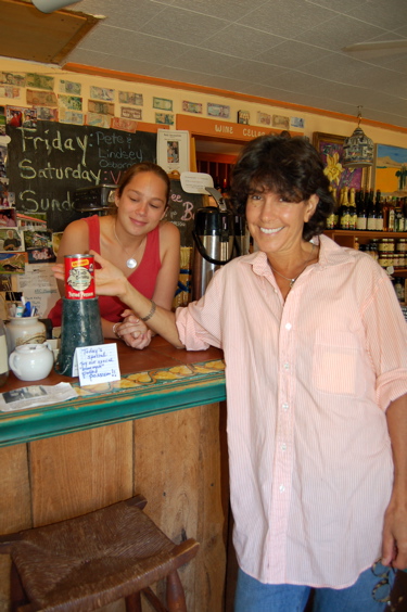
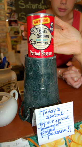
Above top photo left, Sarah Leake, and Kay Pfaltz of Basic Necessities in Nellysford, show off one of their latest delicacies added to the menu. As most of you know, Kay has been gone for the past week in France. When she returned, she added South Carolina Potted Possum to the menu since it has been requested so much over the past year or so. (Okay just kidding!) Actually this was something we got about a week ago and gave to Kay. Don’t ask!
Tuesday was another day unlike Fall. Summer is still holding on and will again today. Our NCL-Weathernet station on Devil’s Knob at The Wintergreen Nature Foundation even made it to 86 degrees on Tuesday afternoon. But … changes are on the way within the next 48 hours. A cold front is working it’s way toward Virginia from the west bringing a roughly 50-50 chance for rain Thursday into Thursday night. If we don’t get it then, we probably won’t have another shot for several days unless something tropical pops up. By the weekend temperature will feel much more like Autumn versus Summer.
I continue to watch numerous areas of disturbed weather out in the Atlantic. There is no immediate threat right now to the U.S. Eastern Coast, but they can’t be totally written off either. Tropical Storm Karen continues to maintain strength, but conditions over the next several days look to squash her from becoming a hurricane. She’ll have to withstand some pretty intense wind shear later this week before much else can happen. Not impossible, but not likely either. Another area of disturbed weather way, way out in the Atlantic is wandering around as well. We’ll see what this one does too. Current images of the projected paths are below.
Tropical Storm Karen project 5 day path
![]()
Invest 97 area of disturbed weather in Atlantic
![]()
And for those of you keeping score at home, The numbers as of 11:59 PM EDT last night
*NCL-Nelson County Life Magazine : Greenfield / Afton, VA
Tuesday High: 93.7°
0.00″ of rain
*NCL-Wintergreen Nature Foundation : Devil’s Knob, VA
Tuesday High: 86.1°
0.00″ of rain
*NCL-Wintergreen Winery @ the foot of Wintergreen Mountain in Beech Grove, VA
Monday High: 94.6°
0.00″ of rain>
*NCL-Delfossee Winery & Vineyard : Near Hickory Creek : Faber, VA
Monday High: N/A°
0.00″ of rain
*Covesville Store : Covesville, VA
Monday High: 89.7°
0.00″ of rain
*NCL-Tiger Fuel – Lovingston, VA
Monday High: 93.4°
0.00″ of rain
*NCL-Mini Tara Vineyards : Arrington, VA
Monday High: 83.8°
0.00″ of rain
Today’s Forecast Map

The National Forecast Map shows high pressure still in control of our weather pulling in warm humid air from the south. It holds on today but weakens tonight in advance of a cold front working toward us providing chances for rain Thursday & Thursday night.
Local forecast
*Today Scattered morning clouds then sunny & continued hot.
*High temps in Nellysford, Crozet, & Colleen again around 90°
*On the mountains above 2000 feet along the BRP, Montebello, Wintergreen, Devil’s Knob, and Love, Morning clouds, then mostly sunny and warm.
Highs top out around 80°
Winds: SSW 5-10 MPH
*Tonight Partly cloudy and mild. Increasingly cloudy by daylight.
*Lows valley around 63°
*On the mountains overnight low near 64° due to the blanket of clouds in the higher elevations.
*Winds: Light-S
Thursday Partly cloudy early, mostly cloudy in the afternoon with a 40% chance of showers or thunderstorms.
*Highs valley 86°
*On the mountains around 78°
Winds: SW 3-5 MPH
*Thursday night: Mostly cloudy with a 50% chance of showers & thunderstorms, mild – Lows generally around 62° valley & 58° mountains.
Winds: Light-W becoming NW by morning
The remainder of the week into the weekend look for a lingering shower Friday morning, with decreasing clouds as the day wears on. Highs in the valley low 80’s – on the mountains around 75° – Overnight lows – low 50’s° valley and upper 40’s mountains. The upcoming weekend looks dry and seasonal with daytime highs in the mid 70’s valley and around 70 mountains.
Whenever or wherever severe weather or news breaks out, we’ll have the latest watches, warnings, and coverage affecting Nelson County, Wintergreen, and nearby counties.
Have a great Wednesday!
Know your Nelson.COM
-T-
