REFRESH Nelson County Life Magazine HERE for the latest updates:
Weathercast by Tommy Stafford, Nelson County Life Magazine
Text updated below photos at 8:00 AM 9-17-07 to reflect mention of some patchy frost last night, as well as low temp readings
AUDIO VERSION OF FORECAST (PC users click play button twice)
Photography by Tommy Stafford
NelsonCountyLife.com : Copyright 2007
Sheeeeeeee’s Back
Basic Necessities
Nellysford, Virginia
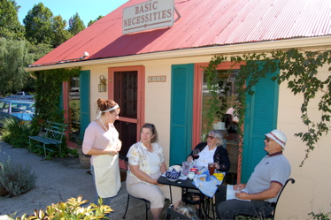

Remember Cassidy? Oh come on you know her, she once was a face at D’Ambola’s Restaurant up in Afton. Earlier this year she moved away to Lynchburg. But, Cassidy decided she wanted to be back closer to Nelson. So we walk into Basic Necessities this past weekend and there she was! We’re glad to see Cassidy back in the area. Note to Basic…good get! Welcome back Cassidy!
It was a perfect weekend to be dining outdoors like the table above that Cassidy was waiting on. Oh, I almost forgot. Before moving on, check out the close up of Sarah Loken below. We didn’t realize it when we were taking the picture, but take a look at her friend!

Like I just mentioned, the weekend was about as perfect as you could get. Though we had some cold temperatures last night in the valley and Saturday night up in the mountains. NCL-Wintergreen Nature Foundation on Devil’s Knob recorded a low around 38 degrees early Sunday morning. Overnight last night we had some cool temps again, but a thin layer of clouds that moved in helped to keep the temps up just a tad in many areas. Though we did make it into the upper 30’s here at NCL-Nelson County Life Magazine in Greenfield just before 7 AM. We even had some patchy frost.. Nothing widespread, but I did see several patches of frost in the pasture. Sunday was a pleasant but cool day with temps topping out near 70 in some locations while Wintergreen never made it out of the 50’s….. almost 60 but never quite made it.
Later this morning we’ll take a look and see if we had any surprise low readings overnight. Sunday night was the last chance for any frost or unusually low temps for the next several days. We will be warming up for the remainder of the week after today. Temperatures will be in the upper 70’s to lower 80’s Tuesday and beyond.
Still keeping an eye out there in the Atlantic on Tropical Depression Ingrid. It’s still holding on as a tropical depression, but not an impressive one. Wind shear, a condition that can limit development, is really working on Ingrid. It’s still not impossible for it to emerge as a storm or even hurricane over the long term, but the next 48 hours will determine that. It could fall completely apart during that time. If it survives then we’ll be taking a closer look.
Projected 5 day path
![]()
And for those of you keeping score at home, The numbers as of 11:59 PM EDT last night
*NCL-Nelson County Life Magazine : Greenfield / Afton, VA
Sunday High: 70.3° @ 3:17 PM
Low this morning: 39.0 @ 6:59 AM
0.00″ of rain
*NCL-Wintergreen Nature Foundation : Devil’s Knob, VA
Sunday High: 59.2° @ 11:52 AM
Low this morning: 40.5° @ 6:27 AM
0.00″ of rain
*NCL-Wintergreen Winery @ the foot of Wintergreen Mountain in Beech Grove, VA
Sunday High: N/A° @ 0:00 PM
0.00″ of rain
*NCL-Delfosse Vineyard & Winery along Hickory Creek : Faber, VA
Sunday High: N/A° @ 0:00 PM
0.00″ of rain
*NCL-Tiger Fuel – Lovingston, VA
Sunday High: 71.8° @ 4:38 PM
Low this morning: 44.1° @ 6:53 AM
0.00″ of rain
*NCL-Mini Tara Vineyards : Arrington, VA
Tues High: N/A° @ 00:00 AM
0.00″ of rain
*Non-NCL Station @ Crozet, VA
Tues High: 67.2° @ 3:41 PM
Low this morning: 44.9° @ 6:35 AM
0.00″ of rain
The National Forecast Map shows high pressure in control today to the north giving us another cool fall like day. By Tuesday our winds switch a little more easterly giving us slightly warmer temperatures. Most of the week looks sunny at this time, though I see a chance for some clouds mid week east of the Blue Ridge if a moisture layer were to work in here from the Atlantic. Still a bit too soon to tell.
Today’s Forecast Map

Local forecast
*Monday Mostly sunny and fall like.
*High temps in Nellysford, Earlysville, & Roseland 73°
*On the mountains above 2000 feet along the BRP, Montebello, Wintergreen, Devil’s Knob, and Love, Mostly sunny and cool.
Highs top out around 60°
Winds: NNE 3-5 MPH
*Tonight Clear and cool.
*Lows valley around 44°
*On the mountains overnight low near 40°
*Winds: NNE 2-4 MPH
Tuesday Continued mostly sunny, warmer.
*Highs valley around 78°
*On the mountains around 68°
Winds: E 3-5 MPH
*Tuesday night: Clear and not as cool – Lows generally low 50’s valley – mid & upper 40’s mountains.
Winds: E 2-4 MPH
The remainder of the week Looks generally sunny each day, though we’ll be watching mid-week for some possible clouds slipping in from the east. Daytime highs in the valley near 80 – on the mountains low and mid 70’s – Overnight lows 50’s valley and upper 40’s to lower 50’s mountains.
Whenever or wherever severe weather or news breaks out, we’ll have the latest watches, warnings, and coverage affecting Nelson County, Wintergreen, and nearby counties.
Have a great Monday!
Know your Nelson.COM
-T-
