REFRESH Nelson County Life Magazine HERE for the latest updates:
Updated: 9-9-07 10:05 AM EDT For Subtropical Storm Gabrielle {SCROLL DOWN FOR UPDATED INFORMATION}
This storm should not be a factor in our weather locally here in Nelson. A frontal system moving our way from the west will affect our weather over the next several days starting late tonight into Monday when chances for rain and showers slowly increase. A complete wrap up in our Monday forecast out at 12:01 AM Monday.
This is the newest area of a low pressure (Invest 91) disturbance way out in the Atlantic. We are watching this for possible tropical storm development and direction over the next few days.
![]()
Animation of tropical storm Gabrielle off East Coast


BULLETIN
TROPICAL STORM GABRIELLE ADVISORY NUMBER 8
NWS TPC/NATIONAL HURRICANE CENTER MIAMI FL AL072007
1100 AM EDT SUN SEP 09 2007…GABRIELLE ABOUT TO MAKE LANDFALL IN NORTH CAROLINA…
A TROPICAL STORM WARNING REMAINS IN EFFECT FROM SURF CITY NORTH
CAROLINA NORTHWARD TO CAPE CHARLES LIGHT VIRGINIA…INCLUDING THE
PAMLICO AND ALBEMARLE SOUNDS.A TROPICAL STORM WATCH REMAINS IN EFFECT IN SOUTHEASTERN VIRGINIA
FOR THE LOWER CHESAPEAKE BAY SOUTH OF NEW POINT COMFORT.FOR STORM INFORMATION SPECIFIC TO YOUR AREA…INCLUDING POSSIBLE
INLAND WATCHES AND WARNINGS…PLEASE MONITOR PRODUCTS ISSUED
BY YOUR LOCAL WEATHER OFFICE.AT 1100 AM EDT…1500Z…THE CENTER OF TROPICAL STORM GABRIELLE WAS
LOCATED NEAR LATITUDE 34.7 NORTH…LONGITUDE 76.3 WEST OR ABOUT 20
MILES… 30 KM…EAST-NORTHEAST OF CAPE LOOKOUT NORTH CAROLINA.GABRIELLE IS MOVING TOWARD THE NORTH NEAR 10 MPH…17 KM/HR.
GABRIELLE IS EXPECTED TO TURN NORTH-NORTHEASTWARD LATER TODAY AND
THEN TO THE NORTHEAST TONIGHT. ON THIS TRACK…THE CENTER OF
GABRIELLE WILL BE MOVING ACROSS THE NORTH CAROLINA OUTER BANKS THIS
AFTERNOON AND THEN BACK OVER THE ATLANTIC TONIGHT.MAXIMUM SUSTAINED WINDS ARE NEAR 50 MPH…85 KM/HR…WITH HIGHER
GUSTS…OVER A SMALL AREA NEAR THE CENTER. SLIGHT STRENGTHENING IS
POSSIBLE AS GABRIELLE PASSES OVER THE OUTER BANKS TODAY.TROPICAL STORM FORCE WINDS EXTEND OUTWARD UP TO 45 MILES…75 KM
FROM THE CENTER.THE MINIMUM CENTRAL PRESSURE JUST REPORTED BY AN AIR FORCE
RECONNAISSANCE AIRCRAFT WAS 1006 MB…29.71 INCHES.COASTAL STORM SURGE FLOODING OF 2 TO 3 FEET IS POSSIBLE WITHIN THE
WARNING AREA AS GABRIELLE PASSES OVER THE OUTER BANKS.GABRIELLE IS EXPECTED TO PRODUCE TOTAL RAINFALL ACCUMULATIONS OF 1
TO 3 INCHES ACROSS THE OUTER BANKS AND SOUNDS OF EASTERN NORTH
CAROLINA AND…WITH ISOLATED MAXIMUM AMOUNTS OF 5 INCHES. RAINFALL
AMOUNTS OF 1 TO 2 INCHES ARE POSSIBLE OVER EXTREME SOUTHEASTERN
VIRGINIA…NEAR THE NORTHEASTERN NORTH CAROLINA BORDER.THERE IS A SLIGHT POSSIBILITY OF ISOLATED TORNADOES OVER THE OUTER
BANKS TODAY.REPEATING THE 1100 AM EDT POSITION…34.7 N…76.3 W. MOVEMENT
TOWARD…NORTH NEAR 10 MPH. MAXIMUM SUSTAINED WINDS…50 MPH.
MINIMUM CENTRAL PRESSURE…1006 MB.AN INTERMEDIATE ADVISORY WILL BE ISSUED BY THE NATIONAL HURRICANE
CENTER AT 200 PM EDT FOLLOWED BY THE NEXT COMPLETE ADVISORY AT 500
PM EDT.
-T-
Updated 9-8-07 7:44 AM EDT for Subtropical Storm Gabrielle formation in Atlantic:
From the National Hurricane Center, FL:
BULLETIN
SUBTROPICAL STORM GABRIELLE ADVISORY NUMBER 2
NWS TPC/NATIONAL HURRICANE CENTER MIAMI FL AL072007
500 AM AST SAT SEP 08 2007…GABRIELLE MOVING WEST-NORTHWESTWARD WITH LITTLE CHANGE IN
STRENGTH…A TROPICAL STORM WATCH REMAINS IN EFFECT FOR PORTIONS OF THE SOUTH
CAROLINA AND NORTH CAROLINA COAST FROM EDISTO BEACH NORTHWARD TO
OREGON INLET…INCLUDING THE PAMLICO SOUND. A TROPICAL STORM WATCH
MEANS THAT TROPICAL STORM CONDITIONS ARE POSSIBLE WITHIN THE WATCH
AREA…GENERALLY WITHIN 36 HOURS.A TROPICAL STORM WARNING COULD BE REQUIRED FOR A PORTION OF THE
TROPICAL STORM WATCH AREA LATER TODAY.FOR STORM INFORMATION SPECIFIC TO YOUR AREA…INCLUDING POSSIBLE
INLAND WATCHES AND WARNINGS…PLEASE MONITOR PRODUCTS ISSUED
BY YOUR LOCAL WEATHER OFFICE.AT 500 AM AST…0900Z…THE CENTER OF SUBTROPICAL STORM GABRIELLE
WAS LOCATED NEAR LATITUDE 30.9 NORTH…LONGITUDE 73.5 WEST OR ABOUT
315 MILES…505 KM…SOUTHEAST OF CAPE LOOKOUT NORTH CAROLINA.THE STORM IS MOVING TOWARD THE WEST-NORTHWEST NEAR 12 MPH. THIS
MOTION IS EXPECTED TO CONTINUE FOR THE NEXT 24 HOURS WITH A GRADUAL
DECREASE IN FORWARD SPEED.MAXIMUM SUSTAINED WINDS ARE NEAR 45 MPH…75 KM/HR…WITH HIGHER
GUSTS. SLIGHT STRENGTHENING IS EXPECTED AS GABRIELLE ACQUIRES
TROPICAL CHARACTERISTICS.WINDS OF 40 MPH EXTEND OUTWARD UP TO 105 MILES…165 KM TO THE NORTH
OF THE CENTER.ESTIMATED MINIMUM CENTRAL PRESSURE IS 1011 MB…29.85 INCHES.
GABRIELLE IS EXPECTED TO PRODUCE TOTAL RAINFALL ACCUMULATIONS OF 2
TO 4 INCHES ACROSS COASTAL SECTIONS OF NORTH CAROLINA…WITH
ISOLATED MAXIMUM AMOUNTS OF 6 INCHES.REPEATING THE 500 AM AST POSITION…30.9 N…73.5 W. MOVEMENT
TOWARD…WEST-NORTHWEST NEAR 12 MPH. MAXIMUM SUSTAINED WINDS…45
MPH. MINIMUM CENTRAL PRESSURE…1011 MB.AN INTERMEDIATE ADVISORY WILL BE ISSUED BY THE NATIONAL HURRICANE
CENTER
I will have more on this Saturday after next advisory comes out at 8 AM EDT
Updated 9-7-07 9:40 PM EDT for possible tropical storm formation off Mid Atlantic Coast:
As of Friday evening Invest 99 shown below in the graphic image has gained 10 mph wind strength now to 45 MPH. There is some though it may reach tropical storm formation at any time.
At 5PM EDT the National Hurricane Center issued the following statement:
Atlantic SPECIAL TROPICAL DISTURBANCE STATEMENT
000
WONT41 KNHC 072106
DSAAT
SPECIAL TROPICAL DISTURBANCE STATEMENT
NWS TPC/NATIONAL HURRICANE CENTER MIAMI FL
505 PM EDT FRI SEP 07 2007THE AIR FORCE RESERVE HURRICANE HUNTER AIRCRAFT INVESTIGATING THE
LOW PRESSURE SYSTEM BETWEEN BERMUDA AND THE SOUTHEAST U.S. COAST
HAS NOT YET IDENTIFIED A WELL-DEFINED CLOSED SURFACE CIRCULATION.
THE AIRCRAFT WILL CONTINUE TO INVESTIGATE THIS SYSTEM…AND IT
COULD BECOME A TROPICAL OR SUBTROPICAL CYCLONE AT ANY TIME AS IT
MOVES WEST-NORTHWESTWARD AT ABOUT 10 MPH. INTERESTS ALONG THE
SOUTHEAST AND MID-ATLANTIC COAST OF THE U.S. SHOULD CLOSELY MONITOR
THE PROGRESS OF THIS SYSTEM…AND TROPICAL STORM WATCHES COULD BE
ISSUED THIS EVENING.$$
FORECASTER KNABB
I will be watching this over the next 24 hours to see what’s going on with it. Right now most models don’t have it affecting Central Virginia. I’m not so sure just yet. We will certainly get some rain from fronts headed our way early next week, but it remains to be seen what this low will do.
More Saturday.
-T-
Updated: 9-7-07 08:40 AM EDT : Continuing to watch for tropical storm development of low out in the Atlantic. Next 24-36 hours critical as to whether this turns into a fairly strong tropical storm..perhaps even a CAT 1 hurricane. Still a tad too early to know for sure, but keep checking today and throughout weekend as data is updated.
-T-
Weathercast by Tommy Stafford, Nelson County Life Magazine
NEW! AUDIO VERSION OF FORECAST
Photography by Heidi Crandall
For Nelson County Life Magazine – Copyright 2007
Brewery Tanks Arrive
Piney River, Virginia
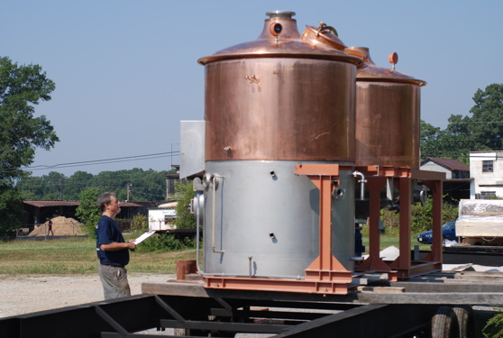
As you know we’ve been following the progress of Nelson’s two microbreweries that are opening within the next year or so. We first told you about Blue Mountain Brewery in Afton that opens next month. And a few weeks ago we told you about Steve Crandall’s progress. In that story the tanks were just leaving Japan on their way to Nelson. Thursday they made it! Steve and his crew offloaded the tanks for storage. Eventually they will be part of his microbrewery in Glen Mary Village on 664 in Beech Grove. The project is scheduled for completion in 2008. Can’t wait for the taste!
Possible tracks of low pressure area in the Atlantic.
![]()
The far red track is a possible scenario around Sunday into Monday, but it’s still too early to know exactly if this will continue to hold together. It would be great if we could get some rain from this, but again I am not convinced we’ll get anything. I’ll have more on this over the weekend as it develops.
The numbers as of 11:59 PM EDT Thursday night
*NCL-Nelson County Life Magazine : Greenfield / Afton, VA
Thurs High: 95.4° @ 4:05 PM
0.00″ of rain
*NCL-Wintergreen Nature Foundation : Devil’s Knob, VA
Thurs High: 83.5° @ 12:58 PM
0.00″ of rain
*NCL-Wintergreen Winery @ the foot of Wintergreen Mountain in Beech Grove, VA
Thurs High: 83.5° @ 12:58 PM
0.00″ of rain
*NCL-Delfosse Vineyard & Winery along Hickory Creek : Faber, VA
Thurs High: 93.9° @ 4:14 PM
0.00″ of rain
*NCL-Tiger Fuel – Lovingston, VA
Thurs High: 94.6° @ 4:25 PM
0.00″ of rain
*NCL-Mini Tara Vineyards : Arrington, VA
Thurs High: 89.4° @ 5:37 PM
0.00″ of rain
The National Forecast Map shows high pressure controlling our weather Friday into the first part of the weekend. By Saturday night the low pressure area I talked about above may begin to influence our weather with clouds spreading in from the east and southeast. By late Sunday night we may begin seeing showers developing and lingering into the middle part of next week as a couple of cold fronts take aim over the next several days. Again, this low pressure area may miss us all together. More info over the weekend.
Today’s Forecast Map

Local forecast
*Today Patchy early morning fog, then sunny & hot.
*High temps in Piney River, Greenwood & Arrington again around 93°
*On the mountains above 2000 feet along the BRP, Montebello, Wintergreen, Devil’s Knob, and Love, Sunny & Warm
Highs top out around 80°
Winds becoming SSW 4-6 MPH
*Tonight Clear & pleasant.
*Lows valley around 60°
*On the mountains overnight low near 57°
*Winds: SSE 2-4 MPH
Saturday Continued mostly sunny & warm.
*Highs valley around 90°
*On the mountains around 81°
Winds: ESE 3-5 MPH
*Saturday night: Becoming mostly cloudy. Lows generally around 65 valley – around 62 mountains.
Winds: SE Light
The remainder of the weekend looks mostly cloudy Sunday with an afternoon high around 85 with light NE winds. Around 80 mountains. Overnight lows – low 60’s valley & near 60 mountains. The chances for showers continues right into next Wednesday with afternoon highs generally in the mid & upper 80’s though the period, cooling to around 80 by Wednesday. Daytime highs may only reach the upper 70’s by late next week on Thursday & Friday.
Whenever or wherever severe weather or news breaks out, we’ll have the latest watches, warnings, and coverage affecting Nelson County, Wintergreen, and nearby counties.
Have a great Weekend!
Know your Nelson.COM
-T-
