REFRESH Nelson County Life Magazine HERE for the latest updates:
Weathercast by Tommy Stafford, Nelson County Life Magazine
NEW! AUDIO VERSION OF TODAY’S FORECAST
Photography by Christina Kline
Nelson County Life Magazine – Copyright 2007
Scenes from the Blue Ridge featured in upcoming TWNF Photography display 9-1-07
Wintergreen, Virginia
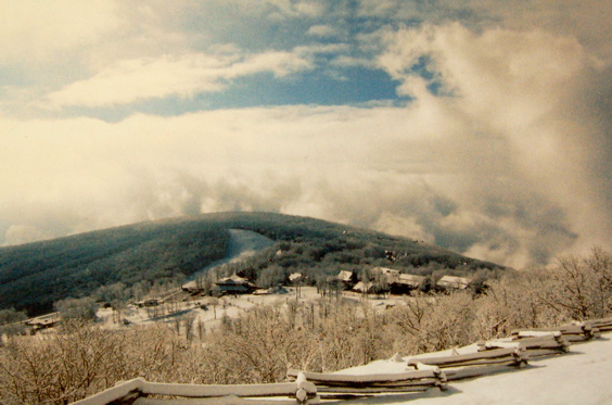
Find out more information about Christina’s upcoming photography reception and show at The Wintergreen Nature Foundation September 1st. Click here for more info. See you there!
Don’t get alarmed by today’s weather picture! We didn’t have a blizzard last night on the mountain. It’s just one of the winter scenes you’ll see this weekend at Christina Kline’s show. But it does make you think of the colder days ahead. Hard to believe summer is just about done.
Wednesday was a much more humid day than any other this week so far. We again started off with some cloudiness early and from time to time throughout the day. By late afternoon we again saw some widely scattered afternoon thunderstorms, mainly west of the BRP. Today will be another hot & more humid day. Chances for thunderstorms are better late this evening and tonight before we break out into sunny skies for the remainder of the holiday weekend.
The numbers as of 11:59 PM EDT Wednesday night
*NCL-Nelson County Life Magazine : Greenfield / Afton
Wed High: 87.3° @ 4:20 PM
0.00″ of rain
*NCL-Wintergreen Nature Foundation : Devil’s Knob
Wed High: 76.8° @ 2:18 PM
0.00″ of rain
*NCL-Wintergreen Winery @ the foot of Wintergreen Mountain in Beech Grove
Wed High: 84.6° @ 11:50 AM
0.00″ of rain
*NCL-Tiger Fuel – Lovingston
Wed High: 88.2° @ 4:38 PM
0.00″ of rain
*Covesville Store : Covesville
Tues High: 83.8° @ 4:08 PM
0.00″ of rain
High pressure weakens today as a cold front moves toward us over the next 36 hours.
Current-Sat Surface Map

The National Forecast Map shows the cold front moving through tonight with high pressure building back in for the Labor Day weekend. Scattered thunderstorms are possible late this evening and tonight with sunny skies moving back in Friday.
Today’s Forecast Map

Local forecast
*Thursday Partly to mostly sunny & hot. Slight chance of late afternoon & evening thunderstorms, more likely tonight.
*High temps in Roseland, Covesville & Wingina around 90°
*On the mountains above 2000 feet along the BRP, Montebello, Wintergreen, Devil’s Knob, and Love, Partly sunny and mild, a scattered storm late.
Highs top out around 81°
Winds SSE 3-5 MPH
*Tonight Mostly cloudy, scattered thunderstorms across 30% of the area.
*Lows valley around 65°
*On the mountains overnight low near 62°
*Winds: SW shifting to the NE by morning 5-10 MPH
Tomorrow Partly sunny and milder with a lingering shower ending by early morning.
*Highs valley around 86°
*On the mountains around 74°
Winds: NE 5-7 MPH
*Tomorrow night: Mostly cloudy in the evening then becoming partly cloudy, pleasant. Lows generally in the low 60’s valley – upper 50’s mountains
Winds: N 4-8 MPH
Labor Day weekend through Monday looks mostly sunny with afternoon highs in the low & mid 80’s valley – 70’s mountains. Overnight lows 60’s valley low 50’s mountains by the weekend.
Remember there’s lots of events going on this weekend, you can get a nice list of them all by clicking on category Datebook on the left.
Whenever severe weather or news breaks out, come here. We’ll have all of the latest watches, warnings, and coverage affecting Nelson County, Wintergreen, and nearby counties.
Have a great Thursday!
Know your Nelson.COM
-T-
