REFRESH Nelson County Life Magazine HERE for the latest updates:
Weathercast by Tommy Stafford, Nelson County Life Magazine
AUDIO WEATHERCAST BACK – MONDAY MORNING
Photography by Heidi Crandall
Nelson County Life Magazine – Copyright 2007
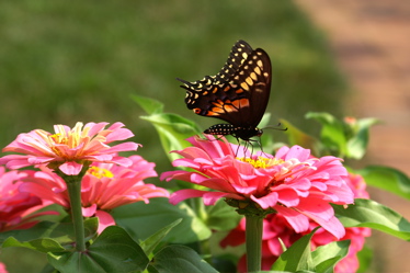
Butterflies in Roseland
Roseland, Virginia
It became pretty severe again Saturday night across much of the northern part of Nelson as well. Many folks in that end of the county got a good soaking, some for the second night in a row. Some power outages were reported in the county as well. CVEC said at one point around 300 customers were in the dark Saturday night.
Thanks to Heidi Crandall for sending in the pic above this weekend. We’ve had a pic or two of the butterflies lately, but nothing this brilliant and up close. Heidi is becoming quite the photographer!
Saturday was hot and humid with air temps at or near 100 degrees in the valley and a heat index near 105°. It even made it to 90.7°, might as well have been 91, degrees on the mountain at Devil’s Knob Saturday afternoon. Jeff Stone’s site at NCL-Wintergreen Winery was the hotspot topping out at 100 degrees.
Sunday will be a mainly cloudy day, though I can’t rule out seeing some sun later in the day as some of the fog and low gray clouds from last nights storms burns off. We’ll still have chances for storms again Sunday afternoon.
Local satellite Sunday morning showed some breaks in the clouds.
The numbers as of 11:59 PM EDT Saturday night
*NCL-Nelson County Life Magazine : Greenfield / Afton
Sat High: 98.4° @ 1:24 PM
1.31″ inches of rain
*NCL-Wintergreen Nature Foundation : Devil’s Knob
Sat High: 90.7° @ 1:30 PM
1.04″ inches of rain
*NCL-Wintergreen Winery @ the foot of Wintergreen Mountain in Beech Grove
Sat High: 100.2° @ 2:23 PM
0.00″ inches of rain
*NCL-Delfosse Vineyard & Winery near Hickory Creek : Faber
Sat High: 99.3° @ 4:15 PM
1.04″ inches of rain
*NCL-Tiger Fuel – Lovingston
Sat High: 99.0° @ 3:30 PM
0.02″ inches of rain
*NCL-Mini Tara Vineyards – Arrington
Thurs High: N/A° @ 0:00 PM
0.00″ of rain
Other area rainfall totals via Nelson County Flood System Reporting stations.
A cold front is working through the area Sunday. It will stall just to our south later today providing chances for thunderstorms again. It won’t be as hot as Saturday as clouds will hang in with light northerly winds as the front slides through.
Current-Sat Surface Map

The National Forecast Map shows the front in the area Sunday providing chances for thunderstorms in the afternoon.
Today’s Forecast Map

Local forecast
*Sunday Not as hot with mostly cloudy skies. Scattered afternoon storms across 40% of the area.
*High temps in Roseland, Greenwood, & Arrington around 88°
*On the mountains above 2000 feet along the BRP, Montebello, Wintergreen, Three Ridges, Devil’s Knob, and Love, Partly cloudy, hot & humid with scattered afternoon thunderstorms.
Highs top out around 78°
Winds NNE 3-5 MPH
*Tonight Mostly cloudy, scattered thunderstorms across 50% of the area.
*Lows valley around 68°
*On the mountains overnight low near 65°
*Winds NE 5-10 MPH
Monday Partly sunny and mild.
*Highs valley around 85°
*On the mountains around 78°
Winds: NE 5-10 MPH
*Monday night: Mostly clear with lows around 63 valley and around 60.
Winds: W 5-10 MPH
Remainder of the week. Chances for rain back in the forecast by Thursday. Temperatures will be more comfortable this week. Though we’ll touch the lower 90’s by mid week.By next weekend we maybe looking at daytime highs in upper 70’s.
When severe weather or news breaks out, come here. We’ll have all of the latest watches, warnings, and coverage affecting Nelson County, Wintergreen, and Central Virginia.
Enjoy your Sunday!
Know your Nelson
-T-

I read your weather blog this morning and it seems you missed all the fun yesterday afternoon. Those clouds you photographed in Nellysford gave us quite a little storm in Afton (I live near Afton Mtn. Vineyards) with just under 2″ of rain as measured in my tomato can and winds of maybe 35-40 mph (a guess). It rained for 45 min. or so and at times so hard that I couldn’t see 100 yds. We even had a little microburst downdraft sort of thing which was confirmed this morning by finding the tops of a couple of 30′ poplars blown out and the branches lying on the ground at 90 degrees to the direction the wind was generally blowing. (I watched all this from my picture window and was greatly entertained) We were sure pleased to get the rain.
Ken
You did get it there Ken! We drove over to Crozet last night the back way through Greenwood and noticed lots of trees down on the road along the way. looks like that storm clipped right along the northern half of the county which would have been right in your back door!
If you go here: http://www.wunderground.com/radar/radblast.asp?ID=FCX®ion=b5&lat=37.95212173&lon=-78.84498596&label=Afton%2c%20VA
Then scroll down below the radar to history and put in yesterday’s dates you can see those intense storms as they rolled across the area. Pretty neat!
Thanks for dropping us a note!
-T-
Tommy,
We picked up 2.0 inches in a manual rain gauge in an open area adjacent to Rodes Farm, just a short distance from Greenfield. It was a great relief since we got little if any on Fri PM.
Not a good night to be reading “Roar of the Heavens”…had to put it down until later.
That Swallowtail is beatiful!
H&E
Wow, that’s great guys. Just in that short distance a difference of about.70″! We actually were sitting on the porch of the Mark Addy watching the storm when lightning hit their transformer! Lots of sparks! But a very nice rain!
-T-