REFRESH Nelson County Life Magazine HERE for the latest updates:
Weathercast by Tommy Stafford, Nelson County Life Magazine
NEW! AUDIO VERSION OF TODAY’S FORECAST
Photography by Tommy Stafford
Nelson County Life Magazine – Copyright 2007
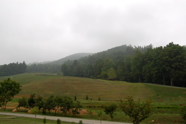
Dlefosse Vineyard & Winery
Faber, Virginia
Finally we’ll begin to see the low gray cloudiness east of the Blue Ridge start to erode Friday into the weekend. Thursday was another cloudy day on the east side of the BRP while folks on the western side saw partly cloudy skies. Unlike the past couple of days, Wintergreen Mountain was pretty much in a shroud of clouds Thursday except for some brief sunshine. You had to get on the western slopes to see any clearing.
Over the weekend look for partly cloudy skies and at least one day of hot weather to return, at least for a bit, before another system makes a run at us on Saturday night into Sunday providing chances for scattered thunderstorms once again. By the start of next week partly cloudy skies return with moderating temps in the middle 80’s.
The numbers as of 11:59 PM EDT Thursday night
*NCL-Nelson County Life Magazine : Greenfield / Afton
Thurs High: 76.6° @ 2:32 PM
0.02″ inches of rain
*NCL-Wintergreen Nature Foundation : Devil’s Knob (**warm spot again***)
Thurs High: 79.7° @ 1:48 PM
0.00″ of rain
*NCL-Wintergreen Winery @ the foot of Wintergreen Mountain in Beech Grove
Thurs High: 76.1° @ 1:35 PM
0.00″ of rain
*NCL-Delfosse Vineyard & Winery near Hickory Creek : Faber
Thurs High: 75.4° @ 11:53 PM
0.00″ of rain
*NCL-Tiger Fuel – Lovingston
Thurs High: 76.8° @ 5:08 PM
0.02″ of rain
*NCL-Mini Tara Vineyards – Arrington
Thurs High: 73.8° @ 8:35 PM
0.00″ of rain
Here are other area rainfall totals via Nelson County Flood System Reporting stations.
An old boundary will finally begin shifting northward out of our area over the next 24 hours allowing for partly sunny skies to build in for part of the weekend. Friday starts off foggy & cloudy with improving conditions as the day wears on.
Current-Sat Surface Map

The National Forecast Map shows the boundary moving north our of the area with partly cloudy skies in the forecast Friday night into Saturday. It will be hot on Saturday with temps in the mid and upper 90’s with a heat index of 100+ degrees.
Today’s Forecast Map

Local forecast
*Friday Mostly cloudy with morning drizzle & fog, with some sunshine in the afternoon. Warmer and humid.
*High temps in Faber, Stoney Creek, & Wingina around 90°
*On the mountains above 2000 feet along the BRP, Montebello, Wintergreen, Three Ridges, Devil’s Knob, and Love, Cloudy & foggy especially on the eastern slopes of the Blue Ridge early, with partly cloudy skies by afternoon.
Highs top out around 80°
Winds S 5-10 MPH
*Friday night Partly cloudy, balmy.
*Lows valley around 70°
*On the mountains overnight low near 67°
*Winds S 5-10 MPH
Saturday Mostly sunny, hot & humid
*Highs valley around 98°
*On the mountains around 86°
Winds: S 5-10 MPH
*Saturday night: Mostly cloudy with scattered thunderstorms across 30% of the area. Lows around 70 valley and upper 60’s mountains.
Winds: W 5-10 MPH
Sunday Partly sunny skies with scattered thunderstorms across 40% of the area. Highs in the upper 80’s valley – around 80 mountains.
The first of the workweek looks partly cloudy with highs in the mid 80’s valley and mid 70’s mountains. There’s a better chance of scattered thunderstorms on the mountains Monday afternoon.
When severe weather or news breaks out, come here. We’ll have all of the latest watches, warnings, and coverage affecting Nelson County, Wintergreen, and Central Virginia.
Have a great Weekend!
Know your Nelson
-T-
