REFRESH Nelson County Life Magazine HERE for the latest updates:
Weathercast by Tommy Stafford, Nelson County Life Magazine
Photography by Heidi Crandall
For Nelson County Life Magazine – Copyright 2007
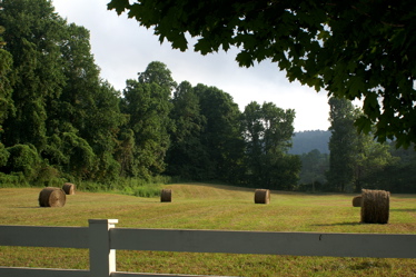
Dew on the morning hay
Roseland, Virginia
Monday was a much less humid day with a really nice northerly wind to actually give us just a tiny prelude to Fall. Yep, I said it Fall. OK, I know when it’s still 90+ degrees it’s hard to think of it, but my mother back in TN always says she can see Fall weeks and weeks before it actually gets here. It’s a gene thing …..
Above, NCL contributing photographer, Heidi Crandall, sent us this scene that’s very much a precursor to fall. Bailed up hay out in the field. You know this late in the summer when you see the hay out in the field Fall’s not far off. But not to worry for you Summer folks, there’s still plenty of warm weather to go! Lots …
The rest of this week will be generally dry with afternoon highs in the 90’s dropping to the 80’s by Friday and the weekend.
Here are the numbers as of 11:59 PM EDT Monday night
*NCL-Nelson County Life Magazine : Greenfield / Afton
Mon High: 94.1 degrees @ 3:46 PM
0.00″ of rain
*NCL-Wintergreen Nature Foundation : Devil’s Knob
Mon High: 81.1 degrees @ 3:20 PM
0.00″ of rain
*NCL-Wintergreen Winery @ the foot of Wintergreen Mountain in Beech Grove
Mon High: 95.7 degrees @ 4:10PM
0.00″ of rain
*NCL-Delfosse Vineyard & Winery near Hickory Creek : Faber
Mon High: 93.9 degrees @ 4:03 PM
0.00″ of rain
*NCL-Tiger Fuel – Lovingston
Sun High: N/A degrees @ 0:00 PM !{OFFLINE} – REPAIRS UNDERWAY!
0.00″ of rain
*NCL-Mini Tara Vineyards : Arrington
Vineyard & Winery near Hickory Creek : Faber
Mon High: 87.1 degrees @ 6:29 PM
0.00″ of rain
On the current surface map, high pressure is in control for most of the week. Though still warm, the humidity will be much less than last week.
Current-Sat Surface Map

On the National Forecast Map, high pressure stays in control through Thursday night when a front makes its way across the area. There is a very slight chance for a passing thunderstorm that night. High pressure and fair weather work back in for the weekend. It will be fairly hot during the period, but again lower humidity than last week.
We’re still watching what is now Tropical Depression #4 a long, long way off the SE U.S. coast, but so far it’s still holding together. We are days, at least a week from knowing what this one might or might not do. I’ll keep an eye out and let you know in future updates if it’s up to anything.
Today’s Forecast Map

Local forecast
*Tuesday Sunny, and less humid.
*High temps in Roseland, Crozet & Schuyler 92 degrees.
*On the mountains above 2000 feet along the BRP, Wintergreen, Three Ridges, Devil’s Knob, and Love, Sunny & nice!
Highs top out around 80 degrees.
Winds NE shifting S in the afternoon 4-8 MPH
*Tuesday night Clear & pleasant.
*Lows valley around 58 degrees.
*On the mountains overnight low of 60.
*Winds SW 2-4 MPH.
Wednesday Sunny & warmer highs around 94 valley. Overnight lows, upper 50’s to low 60’s, dropping to mid 50’s mountains by weekend. Very minimal chances for rain through next weekend.
When severe weather or news breaks out, come here. We’ll have all of the latest watches, warnings, and coverage affecting Nelson County, Wintergreen, and nearby counties.
Have a great Tuesday!
Know your Nelson
-T-

Look at the bright side Tommy, it’s only about 100 days until the start of ski season!
We are so lucky to live in an area where you have four disctinct seasons, but not four extreme seasons.
Best regards,
Paul T Purpura