REFRESH Nelson County Life Magazine HERE for the latest updates:
Weathercast by Tommy Stafford, Nelson County Life Magazine
Photography by Elaine & Henri Weems
For Nelson County Life Magazine – Copyright 2007
Sunrise @ Rodes Farm
Nellysford, Virginia
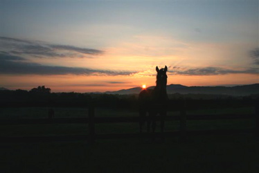
What a near perfect weekend we had across Central Virginia and Nelson County. Faithful NCL web readers Henri & Elaine Weems caught the shot above and sent it to us. What a beautiful sunrise with the horse’s silhouette in the foreground. Got to see both of them Saturday night at Veritas’ Starry Nights. Thanks for the great photo!
This week will still be warm, but not the 102.8 degrees we saw last Friday. We’ll see plenty of 90’s this week, but I’ll take that! Very isolated thunderstorms are in the forecast for this afternoon. We’ll have some humidity this week, but again not as bad as last week. A series of cold fronts will move across the area this week, but we’ll pretty much remain dry. They will help keep the temps in the 90’s vs 100’s.
I am keeping an eye on a developing low off the coast of Africa that has been showing continued development. If it holds together it could impact our weather over the next 10 days. Just keeping tabs. NWS computer runs & discussion show it in the Caribbean by next week.
“Models continue to develop the low coming off west CST of Africa and move it
into Caribbean next weekend.”
Here are the numbers as of 11:59 PM EDT Sunday night
*NCL-Nelson County Life Magazine : Greenfield / Afton
Sun High: 92.3 degrees @ 3:35 PM
0.00″ of rain
*NCL-Wintergreen Nature Foundation : Devil’s Knob
Sun High: 78.6 degrees @ 3:04 PM
0.00″ of rain
*NCL-Wintergreen Winery @ the foot of Wintergreen Mountain in Beech Grove
Sun High: 92.7 degrees @ 2:48 PM
0.00″ of rain
*NCL-Delfosse Vineyard & Winery near Hickory Creek : Faber
Sun High: 91.8 degrees @ 4:40 PM
0.00″ of rain
*NCL-Tiger Fuel – Lovingston
Sun High: N/A degrees @ 0:00 PM !{OFFLINE}!
0.00″ of rain
*NCL-Mini Tara Vineyards : Arrington
Sun High: 91.9 degrees @ 4:24 PM
0.00″ of rain
The current surface map shows a weak frontal boundary working through the area Monday. Widely scattered thunderstorms will be possible with afternoon daytime heating. Most folks will stay dry, but the storms that do fire up have the potential to be strong.
Current-Sat Surface Map

On the National Forecast Map, behind the front high pressure takes control and stays in control of our weather for most of the week. This will provide briefly cooler temperatures on Tuesday before returning to the mid 90’s by Wednesday.
Today’s Forecast Map

Local forecast
*Monday Partly sunny, very widely scattered thunderstorms across 20% of the area in the afternoon..
*High temps in Nellysford, Amherst & Faber 94 degrees.
*On the mountains above 2000 feet along the BRP, Wintergreen, Three Ridges, Devil’s Knob, and Love, Partly sunny. Very widely scattered PM thunderstorms.
Highs top out around 79 degrees.
Winds NNW 5-10 MPH
*Monday night Mostly clear & mild.
*Lows valley around 60 degrees.
*On the mountains overnight low of 61.
*Winds N 3-5 MPH.
Wednesday Hot. Mostly sunny highs in the mid 90’s. Overnight lows, upper 50’s to low 60’s. Slightly cooler mountains. Very minimal chances for rain through next weekend.
Remember when severe weather or news breaks out, come here. We’ll have all of the latest watches, warnings, and coverage affecting Nelson County, Wintergreen, and nearby counties.
Have a great Monday & upcoming week!
Know your Nelson
-T-
