REFRESH Nelson County Life Magazine HERE for the latest updates:
Photography by Tommy Stafford
Nelson County Life Magazine : Copyright 2007
Cheap Gas
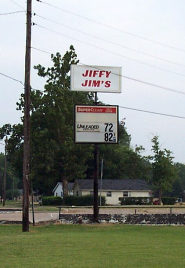
Have you seen how much gas has come down in the past day or so. I was driving past this sign and saw the great prices. OK, maybe I am wishing a bit. I was filing away some photos last night from my old news days in the mid-south and ran across this pic from the Bootheel of Missouri. That’s about 3 hours south of St Louis. I was there in 2002 just after a tornado and remember seeing this sign. Even in 2002 the prices weren’t that cheap! The place had been closed for some time. But I do remember them being 72 cents per gallon, even much less. Those were the days!
Did you feel muggy Tuesday. if not it’s because you were inside! The temps were in the mid and upper 90’s with dewpoints once again in the 70’s. Wintergreen Winery in Beech Grove was the hot spot with an afternoon high just shy of 100 degrees at 99 degrees just after 5PM. That’s hot! A sticky day. Wednesday will be more of the same, with another heat advisory in effect:
HEAT ADVISORY IN EFFECT FROM 1 PM TO 8 PM EDT
WEDNESDAY…FORECAST HIGH TEMPERATURES ON WEDNESDAY ARE EXPECTED TO REACH THE
CENTURY MARK. THIS IN COMBINATION WITH HIGH HUMIDITY VALUES WILL
YIELD HEAT INDEX VALUES IN EXCESS OF 105 DEGREES THIS AFTERNOON.A HEAT ADVISORY MEANS THAT THE COMBINATION OF HOT TEMPERATURES
AND HIGH HUMIDITY WILL COMBINE TO CREATE A SITUATION IN WHICH
HEAT ILLNESSES ARE POSSIBLE. DRINK PLENTY OF FLUIDS…STAY IN AN
AIR CONDITIONED ROOM…STAY OUT OF THE SUN…AND CHECK UP ON
ELDERLY RELATIVES AND NEIGHBORS. NEVER LEAVE PETS OR SMALL
CHILDREN UNATTENDED IN CARS – EVEN WITH WINDOWS CRACKED. THE
INTERIOR OF THE CAR CAN SOAR TO 135 DEGREES IN A FEW MINUTES.
Today should be the worst of the week, then we’ll begin to see slow improvement wih greatly improving temps by the weekend. Even on the mountains it’s been hot for the past couple of days. Remember many folks there don’t even have A/C since they rarely need it except at times like these!
Here’s the numbers from Tuesday: As of 11:59 PM EDT Tuesday night
*NCL-Nelson County Life Magazine : Greenfield / Afton
Tues High: 95.4 degrees @ 4:12 PM
Dewpoint: 80.5 @ 6:37 PM = 66% humidity!
0.00″ of rain
*NCL-Wintergreen Nature Foundation : Devil’s Knob
Tues High: 82.8 degrees @ 2:00 PM
Dewpoint: 69.8 @ 4:00 PM = 67% humidity (as muggy on the mountain as the valley)
0.00″ of rain
*NCL-Wintergreen Winery @ the foot of Wintergreen Mountain : Beech Grove
Tues High: 99.1 degrees @ 5:22 PM ***(HOT SPOT)***
Dewpoint: 76.2 @ 7:12 PM = 64%
0.00″ of rain
*NCL-Delfosse Vineyard & Winery near Hickory Creek : Faber
Tues High: 95.5 degrees @ 4:22 PM
Dewpoint: 77.4 @ 5:02 PM
0.00″ of rain
*NCL-Tiger Fuel – Lovingston
Tues High: 97.0 degrees @ 4:36 PM
Dewpoint: 75.0 @ 9:44 AM
0.00″ of rain
The current surface map has a ridge of high pressure over our area for another 24-36 hours. This will allow temps to reach near 100 degrees today. Very remote chances for isolated t-storms exist.
Current-Sat Surface Map

On the National Forecast Map, the high pressure area stays in control through the day. By tonight a weak front drops in cooling thing slightly on Thursday, if you call low and mid 90’s cooler! More widespread thunderstorms enter the forecast by Friday afternoon.
Today’s Forecast Map

Local forecast
*Wednesday Heat advisory from 1PM until 8PM. Patchy fog & hazy in the morning then mostly sunny hot and humid with heat index of 105-108 – 20% chance of an isolated t-storm.
*High temps in Colleen, Martin’s Store & Rockfish Gap 98 to 101 degrees.
*On the mountains above 2000 feet along the BRP, Wintergreen, Three Ridges, Devil’s Knob, and Love, Early morning fog, then mostly sunny. Hot & muggy.
Highs top out around 88 to 91 degrees.
Winds WSW 4-6 MPH
*Wednesday night Partly cloudy & muggy, isolated t-storms ending after dark.
*Lows valley around 73-75 degrees.
*On the mountains overnight low of 70.
*Winds SW 2-4 MPH.
*Thursday Mostly sunny and hot, but slightly cooler temps.
*High temp around 95 degrees.
*On the mountains Mostly sunny & hot with an afternoon high near 84.
Winds W & Light
Friday Partly sunny, slightly cooler highs in the lower 90’s with scattered afternoon thunderstorms @ 30%.
By the weekend look for temps cooling into the mid & upper 80’s. Overnight lows upper 60’s to around 70.
Remember when severe weather or news breaks out, come here. We’ll have all of the latest watches, warnings, and coverage affecting Nelson County, Wintergreen, and nearby counties.
May your Wednesday be a cool one!
Know your Nelson
-T-
