REFRESH Nelson County Life Magazine HERE for the latest updates:
Photography by Tommy Stafford
Nelson County Life Magazine : Copyright 2007
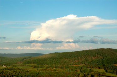
Thunderstorm Anvil from Cardinal Helicopters, Inc Chopper
Al Stacey : Gaia Homes : Pilot
Nelson County, VA
The views you can get here in the mountains of Nelson County are unbelievable. The views you can get here in Nelson County when flying along at 2000 feet are even better! Above is a shot of a thunderstorm anvil off in the distance toward the Blue Ridge. Trivia, once you see a thunderstorm anvil like the one shown above, it means the storm has reached its mature stage and is actually loosing steam so to speak.Though they can still be mean for a long time after reaching a mature stage. The anvil on top is formed when winds way up in the atmosphere blow the top off of the storm forming that classic anvil look. Neat! Al Stacy of Gaia Homes in Nellysford was the pilot in his Robinson R-44 chopper. His helicopter company is Cardinal Helicopters, Inc in Charlottesville. We grabbed this shot on the was back to the landing pad. We’ll be seeing more of these typical summertime thunderheads over the coming days as a stubborn low pressure area keepos chances for scattered thunderstorms in the forecast for the next 4-6 days! More on that in a bit. Thanks Al for the view from above!
Yep it’s finally here, Camp Jeep starts Thursday, though preparations have been underway for the past month. For those of us living here we know what this means. Lots of traffic, lots of people, wheew! But this is a really great time for Jeep owners to get together and enjoy a great time! Camp Jeep runs for 3 days starting Thursday. Yep, Yvette and I will be there bringing you some of the sights and sounds from there as well. Be looking for updates over the next several days. Wish I could say the weather was going to be great, but we do have several chances for thunderstorms for near future. Though it will make some nice muddy trail runs! That is actually fun. Ever been muddin’?
Wednesday will be a mostly cloudy day. Local satellite shows a large area of cloudiness across our area thanks to an upper level low pressure area over Virginia. If you care to see it in action, when you click on thet local sat link, play the animation and you can see the counterclockwise swirl. That’s classic for a low pressure. That low pressure area will hang around for the next few days until we get something in here to push it out. A front will try toward the end of the week but it will be slow to clear out the area.
Here’s the numbers from Tuesday: As of 10AM this morning
*NCL-Nelson County Life Magazine – Greenfield
Tues High: 80.0 degrees @ 13:33 PM
Wed : AM Low: 61.5 degrees @ 3:03 AM
0.02″ of rain since midnight today
*NCL-Wintergreen Nature Foundation @ Devil’s Knob
Tues High: 65.8 degrees @ 10:39 AM
Wed : AM Low: 57.0 degrees @ 12:29 AM
0.04″ of rain since midnight todayNCL-Wintergreen Winery at the foot of Wintergreen Mountain
Tues High: 79.7 degrees @ 4:11 PM
Wed : AM Low: 60.6 degrees @ 12:34 AM
0.02″ of rain since midnight today
*NCL-Delfossee Winery & Vineyard near Hickory Creek : Faber
Tues High: 79.5 degrees @ 12:21 PM
Wed : AM Low: 62.4 degrees @ 3:42 AM
0.02″ of rain since midnight todayNCL-Tiger Fuel – Lovingston
Tues High: 79.3 degrees @ 12:17 PM
Wed : AM Low: 63.1 degrees @ 6:17 AM
0.05″ of rain since midnight today
The current surface map shows an upper level low over the area with high pressure to the north. The low wins out.
Current-Sat Surface Map

The National Forecast Map, shows little movement of the upper low for the next 48 hours keeping chances for thunderstorms and rain in the forecast.
Today’s Forecast Map

Local forecast
*Wednesday Mostly cloudy with showers this morning – then a break with more showers in the afternoon across 60% of the area.
*High temps in Arrington @ Oak Ridge Estate, Rockfish Gap, and Nellysford 81 degrees.
*On the mountains above 2000 feet along the BRP, Wintergreen, Three Ridges, Devil’s Knob, and Love, Mostly sunny and mild with northerly breezes.
Highs top out around 74 degrees.
Winds S 5-10 MPH
*Wednesday night Mostly cloudy with scattered showers & thunderstorms at 50%
*Lows valley around 64 degrees.
*On the mountains overnight low of 63.
*Winds S 5-10 MPH.
*Thursday Partly sunny with lingering showers in the morning – then scattered thunderstorms in the afternoon across 30% of the area.
*High 86 degrees.
*On the mountains Partly sunny with AM showers then scattered afternoon thunderstorms.
Highs top out around 80 degrees.
Winds S 5-10 MPH
Chances for afternoon thunderstorms continues for the extended period. It won’t rain all day everywhere, but showers will be scattered about over the next several days. Best chances are Thursday night through Sunday. Temps are generally in the mid 80’s for daytime highs and overnight lows and mid 60’s for lows. Mountain temps slightly cooler.
Remember when severe weather or news breaks out, come here. We’ll have all of the latest watches, warnings, and coverage affecting Nelson County, Wintergreen, and nearby counties.
Have a great Wednesday!
Know your Nelson
-T-
