Good Thursday to all,
Photo: Tommy Stafford
Nelson County Life Magazine
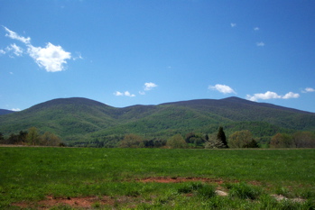
You’ve gotta love living here. Simply taking the trash off gives you views like these looking toward the mountains from the Rockfish Valley!
Yesterday topped out in the upper 70’s and around 80 once again. Clouds hung in there for much of the day due to a weak trough over the area. NCL-Nelson County Life Magazine here in Greenfield, reached a high of 80 degrees yesterday for the second day in a row. NCL-Wintergreen Nature Foundation upon Devil’s Knob, only reached an afternoon high of a cooler 65 degrees. In Lovingston at NCL-Tiger Fuel they reached a high of 76 degrees. To the SE at NCL-Mini Tara Vineyards in Arrington, Mike Patterson’s station there showed a high of 75. Back at the foot of Black Rock Mountain at Jeff Stone’s station in Beech Grove, NCL-Wintergreen Winery recorded an afternoon high of 77 degrees. I think those guys finished up bottling wines there, hopefully. Know they’ve had a busy couple of days!
Today’s current map below doesn’t show much of anything in our immediate area. There are no real features near Virginia. But high pressure continues to gain control over our weather. We will see fewer clouds today as that high takes grip.
Current-Sat Surface Map

On today’s forecast map, the high pressure area sets up just to the NE of Virginia. As the high gets in place, chances for thunderstorms diminish and sunny skies will prevail. It will be a tad warmer today and a continued warm up is still coming our way for the weekend, with someplaces nearing 90 degrees by Sunday.
Today’s Forecast Map

Thursday look for mostly sunny skies. I can’t totally rule out a renegade garden variety thunderstorm late in the day somewhere, but the odds are against it with the dome of high pressure setting up near us. High temps in Gladstone, Avon, and Lovingston will be around 82-83 degrees. On the mountains above 2000 feet along the BRP & Wintergreen, look for sunny skies and afternoon highs to top out around 73 degrees. Winds will be S @ 5-10 MPH Tonight clear lows valley 52-55 degrees – mountains about 48 degrees. Winds south and light around 5 MPH.
Tomorrow look for mostly sunny skies again and temps warming to 86 valley and around 76 mountains.
The upcoming Memorial Day weekend looks nearly perfect, with daytime highs in the mid and upper 80’s – lows around 60. Chances for any orgainzed thunderstorm activity remains low over the weekend. I do see a shot maybe for an isolated thunderstorm on Saturday afternoon as a cold front nears the VA-PA border, but with the high anchored firmly just to the east of Virginia, it will be tough for any kind of real storms to get going.
Have a great Thursday and be looking for a complete Memorial Day weather outlook Friday morning. We’ll also be adding lots of new pics over the weekend from the many events taking place. So be sure to glance from time to time over the weekend!
Tommy

Nice shot Tommy!
Best regards,
Paul