
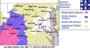
Some of the previously included area in the Winter Storm Warning have been downgraded to advisories (including Nelson) – click here for those details and update as well as latest warnings.
WINTER STORM WARNING
URGENT – WINTER WEATHER MESSAGE
National Weather Service Baltimore MD/Washington DC
754 PM EDT Sun Mar 11 2018
Augusta-Nelson-Western Highland-Eastern Highland-
Central Virginia Blue Ridge-
754 PM EDT Sun Mar 11 2018
…WINTER STORM WARNING NOW IN EFFECT FROM 1 AM TO 2 PM EDT
MONDAY…
* WHAT…Significant snow expected. Total snow accumulations 1
to 3 inches in the valleys and 3 to 6 inches along the ridges
above 2000 feet.
* WHERE…Augusta, Nelson, Highland, and central Virginia Blue
Ridge.
* WHEN…From 1 AM to 2 PM EDT Monday.
* ADDITIONAL DETAILS…Plan on difficult travel conditions,
including during the morning commute Monday. Slippery
conditions may continue into the evening commute Monday along
the ridges. Be prepared for significant reductions in
visibility at times.
PRECAUTIONARY/PREPAREDNESS ACTIONS…
A Winter Storm Warning for snow means severe winter weather
conditions will make travel very hazardous or impossible. If you
must travel, keep an extra flashlight, food and water in your
vehicle in case of an emergency. The latest road conditions for
the state you are calling from can be obtained by calling 5 1 1.
URGENT – WINTER WEATHER MESSAGE
National Weather Service Blacksburg VA
338 PM EDT Sun Mar 11 2018
A complex storm system will develop over the southeastern US
today then begin moving northeast tonight and Monday, eventually
toward the North Carolina coast later in the day Monday. While
there remain some uncertainties, confidence is increasing that
this storm has the potential to bring moderate to heavy snow to
much of the forecast area, especially near and west of the Blue
Ridge, Sunday night through Monday morning.
Ashe-Watauga-Bland-Giles-Wythe-Pulaski-Montgomery-Grayson-Carroll-
Floyd-Craig-Alleghany VA-Bath-Roanoke-Botetourt-Rockbridge-
Franklin-Bedford-Amherst-Mercer-Summers-Monroe-Eastern Greenbrier-
Western Greenbrier-
Including the cities of West Jefferson, Boone, Bland, Pearisburg,
Wytheville, Radford, Pulaski, Blacksburg, Independence, Whitetop,
Troutdale, Volney, Galax, Floyd, New Castle, Clifton Forge,
Covington, Hot Springs, Roanoke, Salem, Fincastle, Lexington,
Buena Vista, Rocky Mount, Bedford, Amherst, Bluefield, Hinton,
Hix, Union, Lewisburg, White Sulphur Springs, Quinwood, Duo,
and Rainelle
338 PM EDT Sun Mar 11 2018
…WINTER STORM WARNING REMAINS IN EFFECT FROM MIDNIGHT TONIGHT
TO MIDNIGHT EDT MONDAY NIGHT…
* WHAT…Heavy wet snow expected. Snow is expected to begin after
midnight and fall heaviest in the morning hours. Total snow
accumulations of 3 to 5 inches, with localized amounts up to 8
inches, are expected.
* WHERE…Portions of central, south central, southwest and west
central Virginia, northwest North Carolina and southeast West
Virginia.
* WHEN…From midnight Sunday to midnight EDT Monday night.
* ADDITIONAL DETAILS…Plan on difficult travel conditions,
including during the morning commute on Monday. Be prepared
for significant reductions in visibility at times.
PRECAUTIONARY/PREPAREDNESS ACTIONS…
A Winter Storm Warning means significant amounts of snow, sleet
and ice will make travel very hazardous or impossible. The latest
road conditions for the state you are calling from can be
obtained by calling 5 1 1.
URGENT – WINTER WEATHER MESSAGE
National Weather Service Baltimore MD/Washington DC
754 PM EDT Sun Mar 11 2018
Rockingham-Shenandoah-Page-Albemarle-Greene-Madison-
Northern Virginia Blue Ridge-Hardy-Western Grant-Eastern Grant-
Western Pendleton-Eastern Pendleton-
754 PM EDT Sun Mar 11 2018
…WINTER WEATHER ADVISORY NOW IN EFFECT FROM 4 AM TO NOON EDT
MONDAY…
* WHAT…Snow expected. Total snow accumulations 1 to 2 inches
in the valleys and 2 to 4 inches along the ridges above 2000
feet.
* WHERE…Portions of central Virginia, the Shenandoah Valley
and the Potomac Highlands of eastern West Virginia.
* WHEN…From 4 AM to noon EDT Monday.
* ADDITIONAL DETAILS…Plan on snow covered and slippery roads,
especially during the morning commute for Monday. Be prepared
for reductions in visibility at times.
PRECAUTIONARY/PREPAREDNESS ACTIONS…
A Winter Weather Advisory for snow means periods of snow will
cause primarily travel difficulties. Be prepared for snow covered
roads and limited visibilities, and use caution while driving.
The latest road conditions for the state you are calling from can
be obtained by calling 5 1 1.
URGENT – WINTER WEATHER MESSAGE
National Weather Service Blacksburg VA
338 PM EDT Sun Mar 11 2018
A complex storm system will develop over the southeastern US
today then begin moving northeast tonight and Monday, eventually
toward the North Carolina coast later in the day Monday. While
there remain some uncertainties, confidence is increasing that
this storm has the potential to bring moderate to heavy snow to
much of the forecast area, especially near and west of the Blue
Ridge, Sunday night through Monday morning.
Surry-Stokes-Rockingham-Caswell-Wilkes-Tazewell-Smyth-Patrick-
Henry-Pittsylvania-Campbell-Appomattox-Buckingham-Halifax-
Charlotte-
Including the cities of Dobson, Danbury, Eden, Yanceyville,
Wilkesboro, Tazewell, Marion, Stuart, Martinsville, Danville,
Lynchburg, Appomattox, South Boston, and Keysville
338 PM EDT Sun Mar 11 2018
…WINTER WEATHER ADVISORY REMAINS IN EFFECT FROM MIDNIGHT
TONIGHT TO MIDNIGHT EDT MONDAY NIGHT…
* WHAT…Snow expected. Snow may mix with sleet at times in the
upper NC Piedmont. Total snow accumulations of 1 to 3 inches,
with localized amounts up to 5 inches, are expected.
* WHERE…Portions of central, south central and southwest
Virginia and north central and northwest North Carolina.
* WHEN…From midnight tonight to midnight EDT Monday night.
* ADDITIONAL DETAILS…Plan on slippery road conditions. The
Monday morning commute will be significantly impacted. Be
prepared for reduced visibilities at times.
PRECAUTIONARY/PREPAREDNESS ACTIONS…
A Winter Weather Advisory for snow means periods of snow will
cause primarily travel difficulties. Be prepared for snow covered
roads and limited visibilities, and use caution while driving.
The latest road conditions for the state you are calling from can
be obtained by calling 5 1 1.
