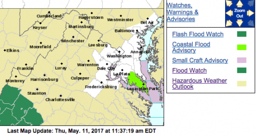
Flood Watches for the majority of the Central Blue Ridge area have been lifted.
Flood Watch
National Weather Service Blacksburg VA
337 PM EDT Thu May 11 2017
…Flash Flood Watch in Effect through this evening for parts of
Southwest and West Central Virginia, along with Southeast West
Virginia…
…Flood Watch in Effect Friday Morning through Saturday Morning
for areas near and west of the Blue Ridge from Lynchburg to
Wilkesboro…
A frontal boundary across the region this evening will drift south
of the area Friday. Bands of showers and storms are expected to
increase across northern and western sections through tonight.
Some of this rainfall will be locally heavy especially where cells
tend to train across the same region. This may result in localized
flash flooding. As the frontal boundary drifts south of the
region Friday into Saturday and low pressure to the west moves
east, widespread moderate to occasionally heavy rainfall will
overspread the area from the south and west, especially Friday
afternoon through Saturday morning. This will lead to a greater
threat for areal flooding as well as river flooding. The ground
across the region is saturated from recent repeated moderate to
heavy rainfall over the past couple of weeks. Additional moderate
to heavy rainfall will quickly result in excessive runoff of water
into area creeks, streams, and rivers. Some rivers across the
forecast area are expected to see moderate rises through the
weekend, especially parts of the New, Greenbrier, and James river
basins.
Ashe-Alleghany NC-Surry-Watauga-Wilkes-Smyth-Wythe-Pulaski-
Montgomery-Grayson-Carroll-Floyd-Roanoke-Patrick-Franklin-Bedford-
Amherst-Henry-
Including the cities of West Jefferson, Sparta, Dobson, Boone,
Wilkesboro, Marion, Wytheville, Radford, Pulaski, Blacksburg,
Independence, Whitetop, Troutdale, Volney, Galax, Floyd, Roanoke,
Salem, Stuart, Rocky Mount, Bedford, Amherst, and Martinsville
337 PM EDT Thu May 11 2017
…FLOOD WATCH REMAINS IN EFFECT FROM 2 AM EDT FRIDAY THROUGH
SATURDAY MORNING…
The Flood Watch continues for
* Portions of North Carolina and Virginia, including the
following areas, in North Carolina, Alleghany NC, Ashe, Surry,
Watauga, and Wilkes. In Virginia, Amherst, Bedford, Carroll,
Floyd, Franklin, Grayson, Henry, Montgomery, Patrick, Pulaski,
Roanoke, Smyth, and Wythe.
* From 2 AM EDT Friday through Saturday morning,
* Widespread rainfall amounts of 1 to 2 inches.
* Rainfall on top of saturated ground in the region from recent
heavy rainfall, could lead to flooding of streams, creeks, and
poor drainage areas. Larger main stem river flooding becomes
increasingly possible as widespread moderate rainfall
overspreads the area Friday into Saturday. Some roads and
property could be impacted.
PRECAUTIONARY/PREPAREDNESS ACTIONS…
A Flood Watch means there is a potential for flooding based on
current forecasts.
You should monitor later forecasts and be alert for possible
Flood Warnings. Those living in areas prone to flooding should be
prepared to take action should flooding develop.
Flood Watch
National Weather Service Blacksburg VA
337 PM EDT Thu May 11 2017
…Flash Flood Watch in Effect through this evening for parts of
Southwest and West Central Virginia, along with Southeast West
Virginia…
…Flood Watch in Effect Friday Morning through Saturday Morning
for areas near and west of the Blue Ridge from Lynchburg to
Wilkesboro…
A frontal boundary across the region this evening will drift south
of the area Friday. Bands of showers and storms are expected to
increase across northern and western sections through tonight.
Some of this rainfall will be locally heavy especially where cells
tend to train across the same region. This may result in localized
flash flooding. As the frontal boundary drifts south of the
region Friday into Saturday and low pressure to the west moves
east, widespread moderate to occasionally heavy rainfall will
overspread the area from the south and west, especially Friday
afternoon through Saturday morning. This will lead to a greater
threat for areal flooding as well as river flooding. The ground
across the region is saturated from recent repeated moderate to
heavy rainfall over the past couple of weeks. Additional moderate
to heavy rainfall will quickly result in excessive runoff of water
into area creeks, streams, and rivers. Some rivers across the
forecast area are expected to see moderate rises through the
weekend, especially parts of the New, Greenbrier, and James river
basins.
Tazewell-Bland-Giles-Craig-Alleghany VA-Bath-Botetourt-Rockbridge–
Mercer-Summers-Monroe-Eastern Greenbrier-Western Greenbrier-
Including the cities of Tazewell, Bland, Pearisburg, New Castle,
Clifton Forge, Covington, Hot Springs, Fincastle, Lexington,
Buena Vista, Bluefield, Flat Top, Hinton, Hix, Union, Lewisburg,
White Sulphur Springs, Alderson, Quinwood, Duo, and Rainelle
337 PM EDT Thu May 11 2017
…FLASH FLOOD WATCH REMAINS IN EFFECT UNTIL 2 AM EDT FRIDAY…
…FLOOD WATCH REMAINS IN EFFECT FROM 2 AM EDT FRIDAY THROUGH
SATURDAY MORNING…
The Flash Flood Watch continues for
* Portions of Virginia and southeast West Virginia, including
the following areas, in Virginia, Alleghany VA, Bath, Bland,
Botetourt, Craig, Giles, Rockbridge, and Tazewell. In
southeast West Virginia, Eastern Greenbrier, Mercer, Monroe,
Summers, and Western Greenbrier.
* Until 2 AM EDT Friday.
* Average rainfall amounts of 1.0 to 2.0 inches, with locally
higher amounts.
* Flash flooding will be possible in areas of heavier showers and
thunderstorms that occur through early tonight, especially in
areas of steep mountainous terrain. Small creeks and streams
will experience sharp rises in these areas. Some roads and
property could be impacted.
PRECAUTIONARY/PREPAREDNESS ACTIONS…
A Flash Flood Watch means that conditions may develop that lead
to flash flooding. Flash flooding is a VERY DANGEROUS SITUATION.
Remember…TURN AROUND…DON`T DROWN!
You should monitor later forecasts and be prepared to take action
should Flash Flood Warnings be issued.
&&
The Flood Watch continues for
* Portions of Virginia and southeast West Virginia, including
the following areas, in Virginia, Alleghany VA, Bath, Bland,
Botetourt, Craig, Giles, Rockbridge, and Tazewell. In
southeast West Virginia, Eastern Greenbrier, Mercer, Monroe,
Summers, and Western Greenbrier.
* From 2 AM EDT Friday through Saturday morning
* Average rainfall amounts of 1.0 to 1.5 inches, with locally
higher amounts.
* Flooding will be possible in areas of heavier showers and
isolated thunderstorms that occur overnight. Larger main stem
river flooding becomes increasingly possible as widespread
moderate rainfall overspreads the area Friday into Saturday.
Some roads and property could be impacted.
PRECAUTIONARY/PREPAREDNESS ACTIONS…
A Flood Watch means there is a potential for flooding based on
current forecasts.
You should monitor later forecasts and be prepared to take action
should Flood Warnings be issued. Those living in areas prone to flooding
should be prepared to take action should flooding develop.


