REFRESH Nelson County Life Magazine HERE for the latest updates:
Photography by Tommy Stafford
Nelson County Life Magazine : Copyright 2007
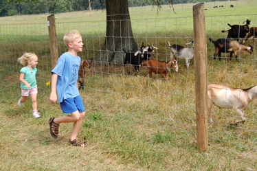
Running with the goats along the Rockfish Valley Loop Trail
Near Beech Grove, Virginia
What a fantastic weekend! The slight threat for rain Sunday never panned out and we were left with great weather for all of the events over the weekend. Above is a shot I grabbed when covering the Rockfish River Day Saturday afternoon just south of Nellysford. That was one of many events we covered. Be sure to check out all of the recent posts on the left hand side of your screen just under the video widget. Speaking of, be sure to play the sights and sounds from this past weekend’s Farmers Market in our newly posted video. If you’ve never gone out to the Farmers Market on Saturday mornings, make it a point to go. It is great!
The weekend was quiet weatherwise. Temperatures worked back into the upper 80’s and low 90’s by Sunday. Look for the humidity to significantly increase again by this afternoon as temps again settle in around 90 for afternoon highs in the valley. We’re headed into an unsettled weather pattern for the next 2-4 days with increased chances for afternoon thunderstorms each day.
Here’s the numbers from Sunday
*NCL-Nelson County Life Magazine – Greenfield
High: 94.3 degrees @ 2:20 PM
0.00″ of rain
*NCL-Mini Tara Vineyards – Arrington
High: 89.2 degrees @ 4:47 PM
0.00″ of rain
*NCL-Wintergreen Winery – Beech Grove at the foot of Wintergreen Mountain
High: 90.7 degrees @ 6:24 PM
0.00″ of rain
*NCL-Tiger Fuel – Lovingston
High: 90.1 degrees @ 3:14 PM
0.00″ of rain
The current surface map shows a cold front going stationary to our north, while a typical Bermuda High pressure area sets up to our southeast. That will leave us with very humid conditions for most of the week. A cold front moves through by week’s end.
Current-Sat Surface Map

The National Forecast Map, shows the front hanging to our north with afternoon thunderstorms breaking out across the area over the next several days. Some of the storms that do get going have the potential to become strong, possibly severe in isolated areas. The best time for storm development will be late afternoon and evening with daytime heating.
Today’s Forecast Map

Local forecast
*Today Partly sunny this morning, partly to mostly cloudy at times by afternoon with scattered thunderstorms across 30% of the area.
*High temps in Nellysford, Lovingston, and Roseland 91 degrees.
*On the mountains above 2000 feet along the BRP, Wintergreen, Three Ridges, Devil’s Knob, and Love, Partly sunny in the morning with mostly cloudy skies in the afternoon with scattered thunderstorms.
Highs top out around 83 degrees. Winds SW 4-8 MPH.
*Tonight Mostly cloudy with scattered thunderstorms in the evening, most ending by midnight. Patchy fog in areas that get rain. Mild and tropical feeling.
*Lows valley around 68 degrees.
*On the mountains overnight low of 67.
*Winds W-5 MPH.
*In the extended outlook
Tuesday Partly sunny, hot & humid with scattered afternoon thunderstorms.
*High 94 valley – 83 on mountains.
Wednesday Partly sunny, hot & humid with scattered afternoon thunderstorms continuing.
Highs around 90 valley – Mountains, Scattered afternoon thunderstorms
High around 82. Overnight lows generally in the mid to upper 60’s valley and mountains.
The remainder of the week looks partly cloudy with chances for scattered afternoon thunderstorms each day through Friday. Afternoon highs cooling to the mid & upper 80’s by week’s end. Next weekend looks sunny & cooler with temps falling to the low 80’s valley / around 74 mountains.
Remember when severe weather or news breaks out, come here. We’ll have all of the latest watches, warnings, and coverage affecting Nelson County, Wintergreen, and nearby counties.
Have a great Monday!
Know your Nelson
-T-
